Online Help for
GMO

"Start GSHAP-Data Mapping Online"
| |
|
|
|
| |
Short description |
| |
GMO is a web-based HTML-form that allows the user to create own GSHAP data maps based on
data of the GSHAP world map. Requests for GSHAP data maps will be sent to our server for further
processing. GMO creates maps with the available GSHAP data of any geographical
region. Different types of legends can also be selected.
Additional features like topography, rivers, overview maps, etc. can be added. |
| |
|
| |
However, if you use the GSHAP maps or data
in publications, please do not forget to quote the GSHAP data. |
| |
Giardini, D., Grünthal, G., Shedlock, K. M. and Zhang, P.: The GSHAP Global Seismic Hazard Map. In: Lee, W., Kanamori, H., Jennings, P. and Kisslinger, C. (eds.): International Handbook of Earthquake & Engineering Seismology, International Geophysics Series 81 B, Academic Press, Amsterdam, 1233-1239, 2003. |
| |
Last but not least, special thanks to Paul Wessel and Walter H.F. Smith for their
great mapping tool GMT
(Wessel & Smith, 1991).
The plate boundaries shown in the maps are by courtesy of Peter Bird
(Bird, 2003).
The data related to his global plate boundary model are vailabe on his
ftp-site.
|
| |
|
| |
|
| |
General Map Properties |
| |
Projection |
|
Possible values: Mercator, Lambert (azimuthal equal area), Lambert (conic conformal), or Albers (conic equal area). For further details, please, look at the GMT website, where all projections are explained in detail. |
| |
Topography |
| |
Possible values: Color, Grey scale. |
| |
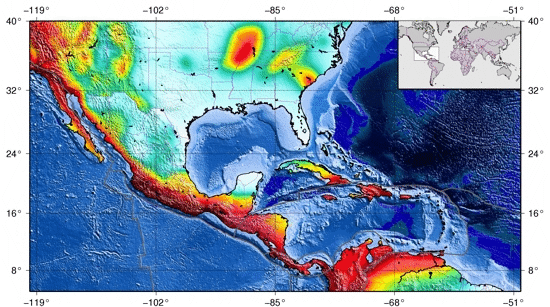
Major rivers, Political boundaries, Plate boundaries, Gridlines |
| |
Colors: Major rivers: light blue; Political boundaries: pink;
Plate boundaries: black; Gridlines: black (Fig. 1). |
| |
Region to plot |
| |
Possible values: longitude [-180..180], latitude[-90..90]. |
| |
 |
| |
Figure 1: Map of Central America (West=-120, East=-50, North=40, South=5) including a global overview map. |
| |
|
| |
|
| |
Inserted Overview Map |
| |
Possible values for the position of the overview map are the four corners: Upper left, Upper right, Lower left, Lower right. |
| |
Range of overview map |
| |
Longitude/Latitude values for the overview map are counted in the same way as for the main map. |
| |
|
| |
|
| |
GSHAP map legend |
| |
It lists the plotted color code for the peak ground acceleration . |
| |
|
| |
Figure 3a: Legend for the GSHAP map using the original color code |
| |
|
| |
|
| |
Figure 3b: Legend for the GSHAP map using the GFZ color code |
| |
|
| |
|
| |
Figure 3c: Legend for the GSHAP map using the GFZ continous color code |
| |
|
| |
|
| |
File Format |
| |
You have the possibilitiy to get your GSHAP data map as ps, pdf or jpg file. The compressed file can be downloaded as zipped tar file archive. |
| |
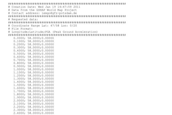
Selected data as ASCII file |
| |
You can get the data plotted on your GSHAP data map as compressed ASCII file (Fig. 5). |
| |
 |
| |
Figure 5: ASCII file containing the GSHAP data. |
| |
|